Cycling the Kathmandu Highlands
55 kilometres. 1,636 metres of climbing. One unforgettable day in the hills above Kathmandu — a lifetime first for every member of the Speedy Tourism family.
When the Team Became the Travellers
Every day at Speedy Tourism and Travels, we design adventures for others — crafting itineraries, recommending routes, sharing the best of Nepal with visitors from around the world. But every once in a while, the best thing we can do is step away from the desk and live the adventure ourselves.
On a clear morning in May 2026, the entire Speedy Tourism family gathered at Balaju — bikes ready, legs fresh, spirits high — and set off on what would become the most demanding, most beautiful, and most unforgettable day any of us had experienced in the Kathmandu Valley. What followed was 55.51 kilometres of highland roads, forest trails, mountain passes, and village paths, culminating in a sun-drenched descent back to Budhanilkantha.
The Long Climb to Kakani
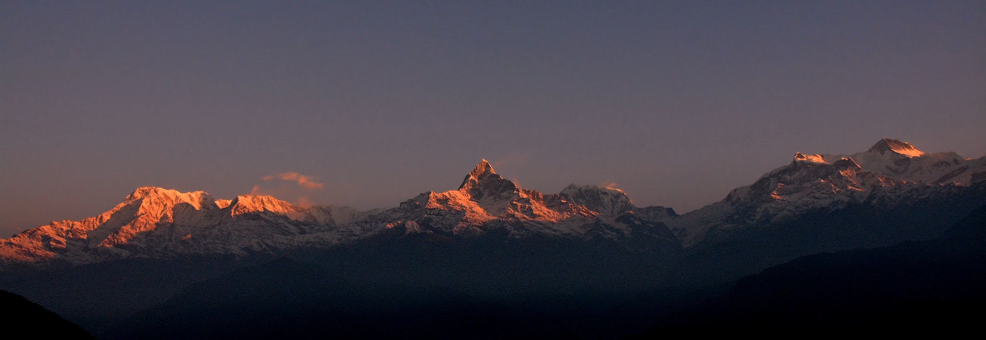
Wheels rolling just after dawn, the city's familiar sounds faded quickly as we turned north and began the long ascent toward Kakani. The road climbs steadily through the northern edge of the valley — pine-scented, quiet, winding through small communities where locals were just beginning their mornings as we pedalled past.
The elevation gain hit early and didn't relent. At 2,073 metres, Kakani is one of the highest accessible points on the valley rim, and the climb demands respect. But the reward more than matches the effort. As we crested the final ridge and Kakani opened up before us, the entire Himalayan panorama — Langtang, Ganesh Himal, the distant white teeth of the high ranges — lay stretched across the northern horizon. We stopped. We stared. Nobody spoke for a moment.
About two hours into the climb, legs starting to speak up, we pulled over at a roadside spot for our first proper break. Simple food, fresh highland air, great company — exactly what tired muscles needed before the ridge ahead.
"Standing at the Kakani ridge with burning lungs, watching the Himalayas catch the morning light — that is the exact moment you remember why you fell in love with this country."— Speedy Tourism Team
After conquering the climb to Kakani and soaking in the Himalayan views, there was only one appropriate way to refuel: a proper Nepali meal. We sat down to the classic dal bhaat — steaming rice, lentil soup, seasonal vegetables, and all the refills you can manage. There is no better cycling food in the world, and nowhere better to eat it than 2,000 metres above Kathmandu with the mountains watching.
Suryachaur — Highlands at Their Most Beautiful
From Kakani, the route continued along the highland ridge toward Suryachaur — and the landscape shifted entirely. Dense forest gave way to open, rolling meadows: wide, grassy, swept by a cool highland wind that smelled of earth and altitude. This is the kind of terrain you don't expect to find within cycling distance of a capital city, and it is utterly disarming in its beauty.
Still riding the satisfaction of the dal bhaat at Kakani, we pushed onward through Suryachaur's open meadows — wide, grassy, swept by a cool highland wind that smelled of earth and altitude. We paused here simply to breathe it in, sitting in the grass, watching clouds drift across the ridgelines in slow, unhurried processions. These are the moments that never make it into brochures but never leave your memory.
Gurju Bhyanjyang — The Hidden Pass
Gurju Bhyanjyang is the kind of place most Kathmandu residents will never discover — a mountain pass tucked into dense forest, quiet, cool, genuinely remote-feeling despite being just hours from the city. The trail narrows here, the canopy closes overhead, and the world shrinks to the sound of tyres on dirt and birdsong from deep in the trees.
For those of us who wanted to stretch their legs further, this section offered irresistible side trails. A short hiking loop from the pass brought us to a clearing with views that the camera simply couldn't capture — the kind you store somewhere behind the eyes and keep. Our max elevation of 2,242 metres was recorded somewhere in this stretch, at the highest point of the entire route.
Then the sky made its own decision. Somewhere in the depths of the forest trail after leaving Kakani, the clouds closed in and the rain came — suddenly, completely, without any apology. Within minutes we were soaked through, every single one of us. Jerseys clinging, water streaming off helmets, shoes squelching at every pedal stroke. The forest, for its part, seemed entirely unbothered — the trees drank it in, the trail turned slick, and we rode on anyway, laughing the kind of laugh you only manage when you're too wet to care anymore.
Danda Gaun — Village Nepal, Unfiltered
Descending from the pass into Danda Gaun, the landscape changed again — from forest to farmland, from wilderness to the warm, textured reality of traditional hill village life. Stone houses with carved wooden windows. Terraced fields in every shade of green. Elderly men sitting in the afternoon sun outside a small chiya pasal. Children watching our convoy of tired cyclists with bright, amused eyes.
We lingered here longer than planned — and that was entirely the right decision. For our team, who spend their days helping international visitors experience Nepal authentically, Danda Gaun was a reminder that the most genuine Nepal exists not in the famous temples or trekking lodges, but in places like this: unhurried, unselfconscious, profoundly alive.
Before the final descent, we made a stop that locals and seasoned cyclists know well — a spot famous for its fresh Himalayan trout. The cold, clean streams flowing off the hills around Kakani and Shivapuri are ideal trout country, and the fish served here — caught fresh, cooked simply — is one of the best-kept food secrets on the entire valley rim. If you ever ride this route, do not skip this stop. You will regret it.
The rain that had drenched us through the forest had followed us all the way to the trout stop — drumming steadily on the roof above our heads as we ate. And then, as if it had somewhere else to be, it stopped the moment our plates were cleared. We sat there for a moment, blinking at the sudden quiet. Dry enough. Warm enough. Full of the best trout any of us had ever eaten. We packed up, clicked into our pedals — and the rain, apparently, had been waiting for exactly this moment. It followed us all the way down into the valley. Every metre of the descent, the clouds came with us — a grey, wet, laughing escort all the way back to Budhanilkantha. Nepal, as always, does things entirely on its own terms.
The Descent — 53.6 km/h of Pure Joy
After the trout stop, came the moment every cyclist lives for: the long, winding descent to Budhanilkantha. Gravity finally, gloriously, on our side. The road ahead curving through forest and farmland in long, sweeping bends. And the rain? True to form, it came with us — a steady grey curtain chasing us all the way down, the whole valley blurred and glistening in the wet.
Our maximum speed of 53.6 km/h was recorded somewhere on that descent — we'll let the Strava data speak to who was responsible. What we can confirm is that there was whooping, there was overtaking, and there was the kind of pure, unguarded joy that you only find at the end of a truly hard day outdoors. Soaked to the bone, wind in our faces, rain at our backs — it was perfect.
We finished at Budhanilkantha as the afternoon light turned silver through the rain — tired, thoroughly soaked, and completely satisfied. 55.51 kilometres. 1,636 metres of climbing. 7 hours and 42 minutes of moving time. Our biggest climb, ever, on record. A personal record for the entire team — earned in sunshine, forest, highland meadows, and a good honest Nepali downpour that followed us all the way home.
- Balaju — Starting Point
- Kakani — 2,073m Himalayan Viewpoint
- Suryachaur — Highland Meadows
- Gurju Bhyanjyang — Mountain Pass (2,242m peak)
- Danda Gaun — Traditional Hill Village
- Budhanilkantha — Finish
- Start early — 6:00–6:30 AM is ideal. Afternoons bring heat and traffic on the lower stretches.
- First tea stop around 8:30 AM on the climb — look for a roadside spot serving boiled eggs and chickpeas to fuel the ridge ahead.
- Plan your Kakani arrival around 11:30 AM for the best dal bhaat. Don't rush past this — it's the highlight meal of the entire route.
- Don't skip the famous trout stop near the end of the ride (~4:30 PM on the descent). Fresh Himalayan trout, grilled simply — a local legend.
- A mountain bike or gravel bike is strongly recommended. Road bikes will struggle on sections near the pass.
- Pack light hiking shoes — the trails around Gurju Bhyanjyang are worth exploring on foot.
- Download offline maps. Mobile signal drops completely in several stretches between Suryachaur and Danda Gaun.
- Best season: October–November and March–April for clear Himalayan views at Kakani.
Want to Ride This Route?
We know this route better than anyone — because we've cycled every metre of it ourselves. Let us plan your perfect Kathmandu Valley cycling or hiking experience.